Nearly 1 million power outages reported in cross-country winter storms, with more snow, icing and blizzard conditions ahead
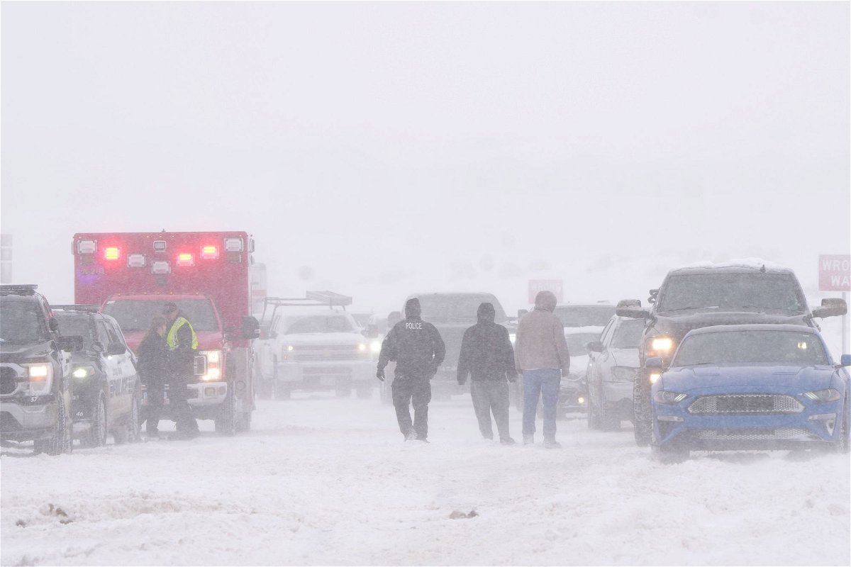
Police and emergency workers try to free vehicles from the snow on Mountain View Parkway in Lehi
By Elizabeth Wolfe, Rob Shackelford and Joe Sutton, CNN
Brutal winter storms brought significant icing, strong wind gusts and heavy snow across strips of the US from California to the Northeast on Thursday, part of a multiday event that has already closed roads and caused numerous power outages — even as the Southeast basks in unseasonably high temperatures.
More than 60 million people were under winter weather alerts early Thursday morning from the West into the northern Plains, Great Lakes region, New York and New England, before warnings began to quickly drop off across the Northern Plains and Great Lakes.
That’s part of storms that already had left nearly one million homes and businesses without power, mainly in Michigan — struck partly by freezing rain and ice that’s damaged utility lines and trees — and other parts of the Midwest, according to tracker PowerOutage.us.
Heavy snow had already hit some of these areas over the past two days — including, as of early Thursday, more than 40 inches in parts of southern Wyoming; up to 32 inches in northwestern Montana; and generally 3-6 inches across Nebraska and the Dakotas.
Search and rescue operations were underway Wednesday evening in several counties across Wyoming to recover motorists that become trapped in heavy snow, the state highway patrol said.
In Minnesota, Minneapolis got more than 13 inches in a three-day period. More than 160 vehicle crashes were reported statewide and dozens of cars spun off roads Wednesday, Minnesota State Patrol spokesperson Lt. Gordon Shank said in a series of tweets.
In Wisconsin — similarly hit by snow since Tuesday in the north and freezing rain Wednesday and Thursday in the south — Gov. Tony Evers declared a statewide energy emergency Wednesday, saying it will “allow for a more swift and efficient restoration of any electric power outages throughout the state,” a news release from his office said.
Perilous travel conditions continued in many of these areas Thursday. Isolated amounts of snowfall of 1-2 inches per hour were reported early Thursday before the heavy snow largely tapered off by the afternoon.
The upper Midwest and Northeast got between 4 to 8 inches Thursday, with some areas seeing even more.
The ice storm warnings Thursday stretched from central Iowa to the Wisconsin-Illinois line and through southern Michigan. These expired during the day, but not before bringing significant icing to parts of Wisconsin and Michigan, including up to three-quarters of an inch in parts of Wisconsin.
Boston could still see mixed precipitation until Friday, with snow up to an inch and ice up to a tenth of an inch as the last of the storm begins to move off shore across the Northeast.
Out west, in an extremely rare event, California’s Los Angeles and Ventura Counties will be under blizzard warnings from Friday morning through Saturday afternoon, the weather said. That will be the first blizzard warning issued by the weather service’s Los Angeles office since 1989, it said.
“Nearly (the) entire population of California will be able to see snow from some vantage point later this week if they look in the right direction,” according to Daniel Swain, a climate scientist at the University of California, Los Angeles. “Snow remains very unlikely in California’s major cities, but it’ll fall quite nearby.”
The National Weather Service in San Diego has issued a blizzard warning for the San Bernardino County mountains from 4 a.m. local time Friday to 4 p.m. Saturday. It’s the first blizzard warning ever issued by the San Diego office, the weather service tweeted.
In the San Bernardino mountains, total snow accumulations of 3 to 5 feet are likely above 5,000 feet. Snow totals of 1 to 3 feet are possible between 4,000 and 5,000 feet. The snow combined with wind gusts of 50 to 60 mph will create visibilities near zero.
Coast-to-coast storms cause disruptions
The treacherous winter storm conditions across wide swaths of the western and northern US have caused major disruptions to daily life in some areas, and prompted local officials to issue warnings against venturing out onto the roads.
More than 1,100 flights within, into or out of the US scheduled were canceled Thursday, according to the tracking site FlightAware. That’s following more than 1,600 flight cancellations Wednesday.
Since the storm began Monday evening, cumulative snowfall has reached dozens of inches in some cities, including 48 inches in Battle Lake, Wyoming, 32 inches in Dupuyer, Montana, and 29 inches in Park City, Utah.
Hazardous conditions have led to safety measures being implemented in multiple states.
• Wisconsin airport preemptively closed: Green Bay’s international airport canceled the remainder of its daily flights Wednesday evening and most of its flights Thursday morning.
• Road closures in several states: Perilous conditions triggered highway closures on several states Wednesday, including South Dakota, Wyoming, Arizona, North Dakota and Minnesota.
• Maine government offices closed: Gov. Janet Mills announced that state offices would be closed Thursday as the storm “is expected to bring significant snowfall to most of the state,” her office said in a release.
Abnormal heat across the Southeast
The Southeast and even areas up into the Ohio Valley continued to see unusually high temperatures Thursday. At least 50 record high temperatures were reported, whether for Thursday’s date, for the month of February, or even for the season, from Jacksonville, Florida, to Columbus, Ohio.
More than 30 daily record highs were recorded in the Southeast and parts of the Appalachians and lower Midwest on Wednesday.
The dueling winter storm and southern heat wave created a stark 100-degree temperature difference between the Northern Rockies and the South earlier this week.
By the end of the week, more than 100 record highs are possible stretching from the Gulf of Mexico up to the Great Lakes.
The region also experienced severe storms throughout the Mississippi River Valley on Wednesday, with more than 30 storms reported across the region.
Correction: A previous version of this story incorrectly stated which city reached 87 degrees Wednesday. It was Naples, Florida.
The-CNN-Wire
™ & © 2023 Cable News Network, Inc., a Warner Bros. Discovery Company. All rights reserved.
CNN’s Taylor Ward, Aya Elamroussi and Eric Levenson contributed to this report.