Wildfire forces evacuation of southwest Nebraska towns, burns over 40,000 acres
Fifteen days after a wildfire consumed 35
By Brian Neben
Click here for updates on this story
CAMBRIDGE, Nebraska (Lexington Clipper Herald) — Fifteen days after a wildfire consumed 35,000 acres in Gosper and Furnas counties, a wildfire that broke out on Friday, April 22 forced the evacuation of several southwestern Nebraska communities and has burned over 40,000 acres, so far.
While the fire weather situation has been volatile for weeks, April 22 featured a number of factors that brought fire conditions to a peak.
The prior lack of rainfall had extended Extreme Drought Conditions (D3) down into the local area and where the fires occurred in Red Willow and Furnas counties. Some areas haven’t seen an inch of precipitation between March 1 and April 20.
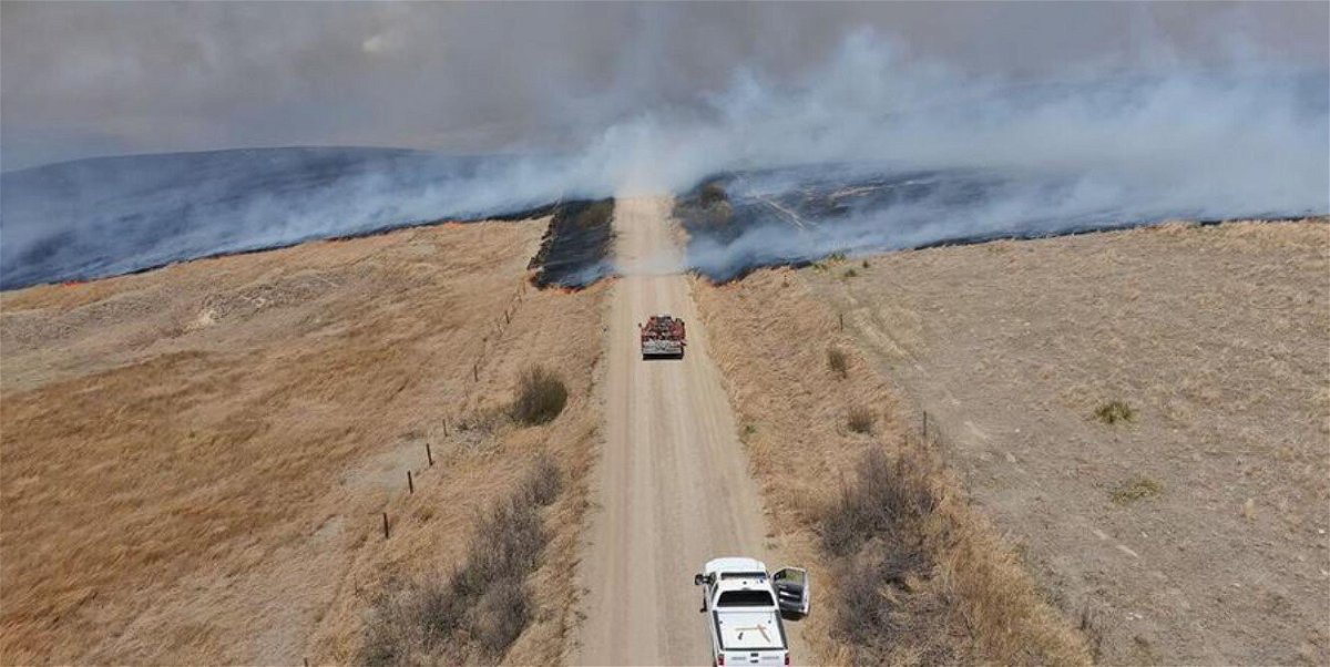
The National Weather Service – Hastings had also issued a high wind warning on Friday due to the wind gusts. Maximum wind gusts were around 60 to 70 mph. The NWS Goodland, Kan., office reported an 82 mph gusts near Trenton.
The fire began in Norton County, Kan. and quickly spread across the state line, driven by the high winds out of the south.
Cambridge, Bartley, Indianola and Wilsonville, communities in Furnas and Red Willow counties, were given evacuation orders Friday evening after a fire began to spread north and eventually west as strong winds gusting over 70 mph fueled the flames.
Lexington Fire Chief Bo Berry said they received a call around 7 p.m. to help fight the fire. A crew of four in a grass rig was operating near Cambridge until midnight when they suffered tire trouble.
More firefighters went down to help get the rig back up and running by midnight. Berry said he was in communication with the crew once every hour, owning to the “extremely dangerous situation.”
In total, the crew was on scene for around 12 hours. Berry said the situation was similar to the Gosper/Furnas County wildfire earlier this month, owning to the high winds and dangerous fire conditions.
Evacuation orders were lifted for all towns around 12:30 p.m. Saturday. However, around 1:15 p.m., officials said the fire flared up again south of Cambridge, along the border of Furnas and Red Willow counties. Residents of Cambridge were told to be on standby in case the evacuation order was reinstated.
A retired Cambridge fire chief was killed as a result of the fire.
“Alyssa Sanders, with NEMA, said 66-year-old John P. Trumble, of Arapahoe, was overcome by smoke and fire after his vehicle left the road Friday because of poor visibility from smoke and dust, his body was found early Saturday,” according to the Associated Press.
At least 15 firefighters have been injured battling the blazes, including five who were hurt in the fire that killed Trumble.
The fire had burned more than 78 square miles in Red Willow, Furnas and Frontier counties by Sunday afternoon.
“The Road 702 Fire is estimated at 50,000 acres. A Multi-Mission Aircraft (MMA) from Colorado is currently flying the fire and will be able to provide a more accurate size as well as identify locations within the fire area where hot spots exist. This will allow firefighters to focus on areas that still pose a risk to life and property,” according to the Nebraska Emergency Management Agency (NEMA).
“As a fire gets larger and additional resources are brought in, the fire is broken into geographic areas called Branches and Divisions to help focus suppression efforts and to help with supervisory span of control. We will use these terms in our updates to provide specific information about each part of the fire perimeter,” NEMA stated.
“Branch One encompasses the area from Cambridge west along the fire edge and south to Lebanon. Firefighters in this area are continuing to secure existing fire lines by mopping up any hotspots that remain. Primary areas of concern are timbered draws especially in the Republican River breaks,” according to NEMA.
“Branch Three encompasses east and south perimeters of the fire from Cambridge south to Wilsonville and into Kansas. Firefighters in this area are continuing to mop up and secure the fire line along the Republican River and US-6 working south towards Wilsonville,” NEMA stated.
Areas of concern are timbered draws and hay bales near the fire edge. Additional operations personnel are scouting the fire edge south of Wilsonville and coordinating with resources in Kansas.
The public is being asked to avoid the area and to use caution when driving in areas with reduced visibility due to smoke and dust.
There was 47 percent containment of the fire as of Tuesday morning according to the Nebraska Forest Service.
“In wildfire response, “containment” refers to a line built or established around a fire’s perimeter that will keep it from growing under almost any conditions. The most common and effective way of achieving that perimeter line – sometimes called a fire line – is to remove all vegetation and burnable fuel in the fire’s path, making any further expansion impossible,” the Nebraska Forest Service stated.
Blazes have been reported in 14 counties in around the state since Friday, including Perkins, Dundy, Burt, Butler, Scotts Bluff, Cheyenne, Duele, Blaine, Cherry, Brown and Thomas counties. NEMA said those other fires had either been extinguished or mostly contained by Sunday afternoon.
Please note: This content carries a strict local market embargo. If you share the same market as the contributor of this article, you may not use it on any platform.