
Idalia weakens to a tropical storm after pummeling Florida with record-breaking storm surge and disastrous flooding. Now Georgia and Carolinas are at risk
Originally Published: 30 AUG 23 01:13 ET
Updated: 30 AUG 23 16:59 ET
By Nouran Salahieh, Holly Yan and Christina Maxouris, CNN
Editor's note: Affected by the storm? Use CNN’s lite site for low bandwidth.
(CNN) — [Breaking news update, published at 5:00 p.m. ET]
Idalia continues to weaken as it moves over southeastern Georgia and is now a tropical storm with winds of 70 mph, according to the 5 p.m. ET advisory from the National Hurricane Center.
[Previous update, published at 4:55 p.m.]
Hurricane Idalia is threatening parts of Georgia and the Carolinas with vicious winds and dangerous flooding as it continues its violent trek across the Southeast, after ripping off roofs and engulfing Florida cities in floodwater.
In Florida’s Crystal River, water levels appeared to be receding but a high tide was still expected, making the existing flooding even more dangerous, city council member Ken Frink told CNN Wednesday afternoon.
“Right now, it’s still a catastrophic event,” Frink said. “All the homes around us, they’re all underwater.”
In nearby coastal Pasco County, just north of Tampa, roughly 6,000 homes were “inundated with water,” according to one official.
“Many of them that we’re seeing have major damage. That means that we have water at least 18 inches or higher that have gone into these homes,” Laura Wilcoxen, the Pasco County Emergency Management assistant director, told CNN.
Idalia is now lashing a 250-mile swath of the Southeast.
As of Wednesday afternoon, the storm was whipping maximum sustained winds of 75 mph – with even more ferocious gusts – and though it is forecast to continue weakening, it could still bring powerful winds, intense flooding and tornadoes across parts of southern Georgia and the Carolinas, according to the National Hurricane Center. Flash flooding and river flooding is likely across Georgia and the Carolinas through Thursday, the center warned.
In storm-ravaged Florida, authorities warn that while the sky there may be clearing, the danger is not yet over.
“We still have a lot of water coming into the Tampa Bay area, make sure that you’re not driving through any standing water,” Wilcoxen said.
In Citrus County, which includes Crystal River, Sheriff Mike Prendergast told CNN the hurricane’s effects will continue “to play out for a long time.”
“Where I’m standing right now could potentially be under 6 feet of water by the time we get the high tide” late Wednesday afternoon, he said.
“We fear that residents will walk outside, see it’s sunny outside and think everything’s fine. But there’s more water coming,” warned Rob Herrin, spokesperson for Hillsborough County Fire Rescue. “There’s still so many hazards after the winds and rains have cleared.”
Prendergast urged people not to venture into the water filling the streets.
“Don’t get out onto that water, because it is salt water mixed in with a lot of other things,” the sheriff said.
“It’s going to destroy your vehicles, and then it’s going to give you a costly repair bill whenever you get past the storm.”
2 men killed in weather-related crashes
Idalia slammed Florida’s Big Bend area – the nook between the panhandle and peninsula – near Keaton Beach Wednesday morning at a dangerous Category 3 strength. That part of the Gulf Coast hasn’t seen such deadly storm surge and wind gust for at least 125 years.
“Conditions will gradually start to improve in Florida later today, but the water levels are going to remain elevated – especially along the Big Bend coast down into Tampa through much of the day today,” National Hurricane Center Director Michael Brennan said Wednesday.
FOLLOW HURRICANE IDALIA LIVE UPDATES
At least two men were killed in separate, weather-related car crashes Wednesday, Florida Highway Patrol Sgt. Steve Gaskins said. Their deaths mark the first reported fatalities linked to Hurricane Idalia.
In the vulnerable island city of Cedar Key, a water level record was shattered amid 8 to 9 feet of storm surge. And the water was still rising fast – predicted to hurl seawater as high as halfway up the second floor of an average building.
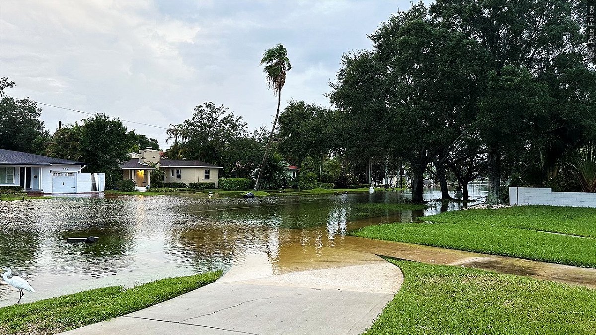
Swaths of Tampa, St. Petersburg and Fort Myers Beach also have been engulfed by wind-whipped seawater and torrential rain.
‘We’re effectively cut off from the world now’
The island city of Cedar Key looked “almost apocalyptic” even before landfall, resident Michael Bobbitt said Wednesday morning. Hours later, the disastrous storm surge had overwhelmed it.
“We’re effectively cut off from the world now,” Bobbit said. “It’s going to get a lot worse, and I’m really fearful for what we’re going to find in some of the low-lying areas and some of our older, more infirm citizens today.”
Storm surge accounts for about half of all hurricane-related deaths, the National Oceanic and Atmospheric Administration said.
Here are other developments from across the region:
• Air travel halted: Hundreds of flights have been canceled as Tampa International Airport suspended commercial operations and St. Pete-Clearwater International Airport Terminal building closed Tuesday.
“Tampa airport is going to reopen for incoming flights at 4 p.m.,” DeSantis said Wednesday. “By 3 a.m. tomorrow, it will be fully reopened.” The governor said airports in Gainesville and Tallahassee are also scheduled to reopen Thursday morning.
In Georgia, the Savannah/Hilton Head International Airport announced Wednesday flights out of the airport were canceled for the rest of the day.
• Bridges are shut down: Major bridges connecting St. Petersburg to mainland Florida have been closed, according to online data from the Florida Department of Transportation. Road access to smaller barrier islands also is closed, Pinellas County Emergency Management said on X, formerly Twitter.
• Power knocked out: About 262,000 homes, businesses and other power customers in Florida and about 208,000 in Georgia had no electricity around 4 p.m. Wednesday, according to PowerOutage.com.
• Evacuations in at least 28 counties: Alachua, Baker, Citrus, Dixie, Franklin, Gilchrist, Gulf, Hamilton, Hernando, Hillsborough, Jefferson, Lafayette, Leon, Levy, Madison, Manatee, Marion, Nassau, Pasco, Pinellas, Putnam, Sarasota, Suwannee, Sumter, Taylor, Union, Volusia and Wakulla have all issued evacuation orders, some mandatory. An emergency declaration covers 49 of 67 Florida counties.
• Thousands are in shelters: About 4,500 people are taking refuge in shelters in the impact area, Red Cross data Wednesday shows. The most people – 442 – were at a site in Largo, Florida, with more than 100 shelters open across the storm’s path, the aid group said.
• Hospitals suspend services: Patients were being transferred from at least three hospitals: HCA Florida Pasadena Hospital, HCA Florida Trinity West Hospital and HCA Florida West Tampa Hospital. Meanwhile, Tampa General Hospital was constructing a water-impermeable barrier to stay open for emergency care.
• Schools and universities close: 50 county school districts have issued closures, as did dozens of college and university systems across Florida.
• Thousands of inmates evacuated: About 4,000 inmates were evacuated or relocated to facilities better equipped to handle the storm, according to the Florida Department of Corrections.
What to expect next
Idalia’s center is forecast to move near or along the coasts of Georgia, South Carolina and North Carolina late Wednesday and Thursday, the National Hurricane Center said.
“Idalia is likely to still be a hurricane while moving across southern Georgia, and possibly when it reaches the coast of Georgia or southern South Carolina late today,” the hurricane center said Wednesday morning.
North Carolina and Georgia have declared states of emergency as they prepare for floods and hurricane force winds.
In Georgia, Savannah is likely to see tropical storm conditions through Wednesday night, with flooding and storm surge between 3 and 5 feet and possible tornadoes. The storm’s outer bands could hit Atlanta with thunderstorms and winds up to 20 mph.
Charleston, South Carolina, into early Thursday could see tropical storm conditions, including heavy rain, flooding, tornadoes and storm surge of 3 to 5 feet.
And in Wilmington, North Carolina, tropical storm conditions are possible into Thursday, with heavy rain, flooding and storm surge of 1 to 3 feet.
The-CNN-Wire
™ & © 2023 Cable News Network, Inc., a Warner Bros. Discovery Company. All rights reserved.