
Storm shifts into East Coast after causing ‘catastrophic’ flooding in Georgia and Tennessee

By Meteorologists Chris Dolce, and Mary Gilbert, and CNN’s Kate S. Petersen
(CNN) — The first significant rainfall in weeks is falling along parts of the Northeast coast on Friday from the same storm that produced historic and catastrophic flooding on the Georgia and Tennessee border Wednesday into Thursday morning.
⛈️☔️Get your forecast and track the storm in the CNN Weather app
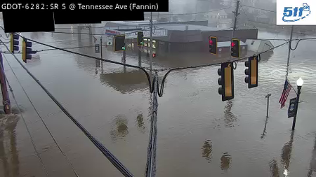
More than 100 people had to be rescued as feet of floodwater overwhelmed homes and businesses in McCaysville, Georgia, and Copperhill, Tennessee, after downpours swelled their shared river to a new record high.
Extreme flooding like this is not expected along the East Coast, but the downpours could still cause flash flooding despite dry ground after weeks without rain.
East Coast next up for flood threat
Heavy rain is underway in coastal portions of the Northeast and Mid–Atlantic and is expected to last through Friday night or possibly early Saturday morning.
Flooding could unfold if enough rain falls too fast. A Level 2 of 4 risk of flooding rain is in place for southern New England, including Boston and Providence, Rhode Island, where the heaviest rain is forecast.
Totals of 2 to 4 inches are expected there, but a few locations caught under repeated heavy downpours could deal with up to 6 inches. It’s difficult to pinpoint exactly where that could occur since it will depend on if one area gets hit repeatedly by the heaviest rain.
Flooding is most likely in urban and low-lying areas that are less capable of handling heavy rain.
A Level 1 of 4 risk of flooding rainfall is also in place on Friday from the New York City area to southeastern Virginia and northeastern North Carolina. These areas could deal with ponding on roadways, delays at airports and isolated flash flooding.
Most of the East Coast will dry out by Saturday afternoon, but some showers could develop deeper inland.
Catastrophic flooding swamps towns in Georgia, Tennessee
The rain came fast and furious on Wednesday night, and when it had stopped, a few spots in North Georgia had picked up 6 to 11 inches of rain.
The high end of that range is a 1 in-1,000 year rainfall for 12 hours — a rate that has only a 0.1% chance of happening in a given year, under normal circumstances, according to the National Weather Service. But extreme rainfall is becoming more common as planet-warming pollution pushes temperatures higher as warmer air can hold more moisture.
As a result, flash flood emergencies — the highest level of flood warning — were issued Thursday morning for McCaysville, Georgia, in Fannin County, and Copperhill, Tennessee, in Polk County.
Record flooding struck there along a river known as the Toccoa River in Georgia and the Ocoee River in Tennessee across the border.
Emergency responders from both states worked together to reach stranded residents. As of late Thursday afternoon, over 100 people had been rescued across Georgia and Tennessee, according to Kristin Coulter with the Tennessee Emergency Management Authority. Coulter said the agency was not aware of any significant injuries or missing people at that time.
A separate flash flood emergency was also issued Wednesday night for other parts of Fannin County and neighboring Gilmer County in Georgia. Emergency management in Fannin and Gilmer counties in Georgia reported “multiple homes flooded and some completely surrounded by water” early Thursday morning.
McCaysville Police Chief Michael Earley called flooding in his city “catastrophic.” Swift water teams rescued roughly 57 people overnight in Fannin County, and evacuations were ordered early Thursday for McCaysville residents along the river, officials said.
Georgia Gov. Brian Kemp declared a state of emergency for Fannin, Gilmer, Murray and Union counties Thursday afternoon. The Tennessee Emergency Management Authority activated its Operations Center to Level 4 for the Polk County flooding.
The Polk County sheriff and McCaysville police chief ordered mandatory curfews for flood-impacted areas from 6 p.m. to 6 a.m.
Multiple roads are blocked by mudslides or have been washed away completely, and propane tanks were dislodged and floating in floodwater, Fannin County Fire Chief Larry Thomas told CNN. One tank in McCaysville caught fire and exploded. A responding firefighter suffered minor injuries, Earley said.
There were also at least four structure fires Wednesday night, which Thomas believes were caused by lightning. Two of the structures, one a home, were lost after floodwater prevented fire trucks from responding.
A few spots in North Georgia picked up 6 to 11 inches of rain. The high end of that range is a 1 in 1,000 year rainfall for 12 hours — a rate that has only a 0.1% chance of happening in a given year, under normal circumstances, according to the National Weather Service.
The-CNN-Wire
™ & © 2026 Cable News Network, Inc., a Warner Bros. Discovery Company. All rights reserved.
CNN’s Sara Smart and CNN Meteorologists Brandon Miller and Briana Waxman contributed to this report.