Live Storm Updates: All evacuation orders & warning in Riverside County lifted as storm leaves Southland
5:00 p.m. Riverside County announced that all evacuation orders and warnings have been lifted in the county.
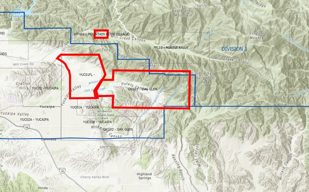
San Bernardino County have also lifted all their evacuation warning for the communities of Mountain Home Village, northeast Yucaipa, and Oak Glen.
1:15 p.m. Showers continue to move in from the southwest, bringing in more rain for the Valley through early evening, with the potential to add up to another 0.20" of rainfall to earlier totals. As with Monday's storm, cold air is pushing snow showers to lower elevations, even near the base of the mountain in Palm Springs.
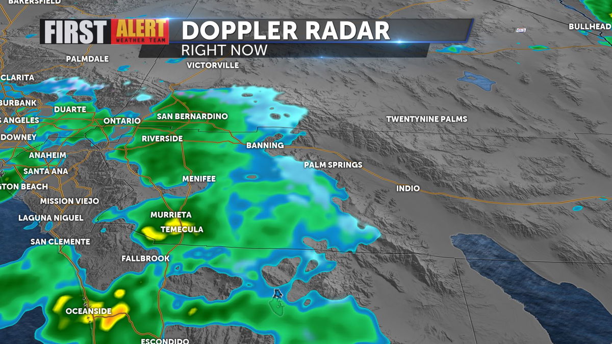
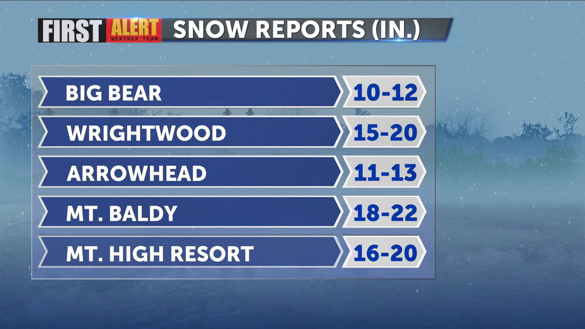
11:00 a.m. Snowfall continues in the mountains of Riverside and San Bernardino counties, with increasing accumulation through the morning.:
Gusty winds sweep through the Valley and lower elevations as the low passes to our North. Gusts up to 15-20mph expected.
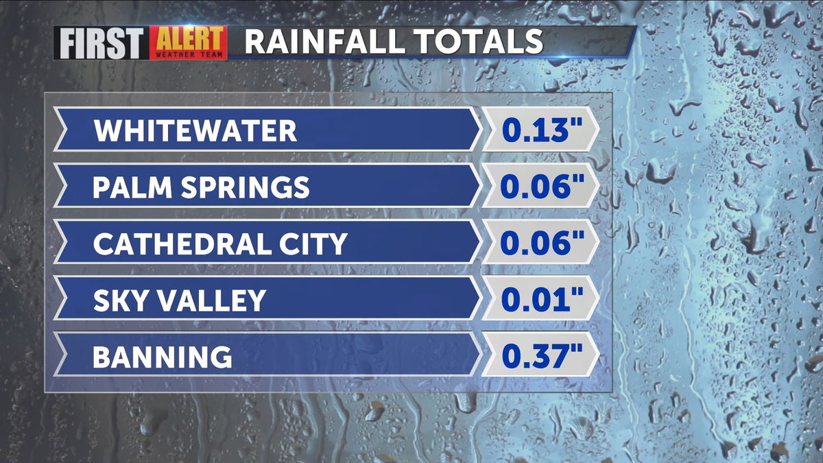
6:45 a.m. Updated rainfall totals:
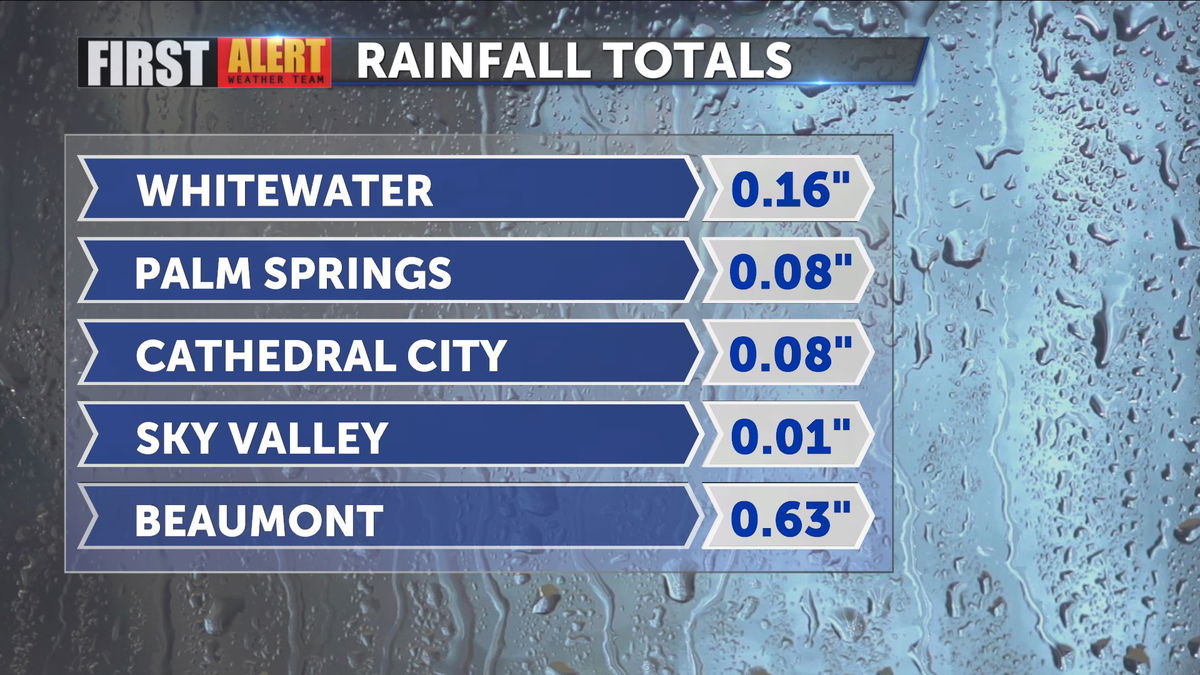
5:40 a.m. Rainfall totals from Valley and nearby locations thus far:
5:30 a.m.
CABAZON - Police and firefighters were on the scene of an 8 vehicle collision on Interstate 10 eastbound that was reported at 4:53 a.m. The collisions were reported just east of Main Street. Traffic was slowed in the area as crews worked to clear the wreckage. There was no immediate word on injuries, but rain was falling in the area.
1:20 a.m. Friday
Jurupa Valley now up to 0.56" and 0.07" has been picked up in Beaumont along I-10. Snow was falling 5 miles south of Oak Glen at 12:20 a.m.
12:00 a.m.
Radar shows rain has made its way east across the Inland Empire and into the San Gorgonio Pass. Just to our west, Jurupa Valley has recorded 0.44" and 0.22" has accumulated in San Bernardino.
8:30 p.m.
Haley Clawson continues to track the storm. As of 8:30 p.m., she writes that the storm is entering Orange and San Bernardino counties. The storm is projected to arrive in Riverside County at around 11 p.m.
There are no new evacuation order or warning in effect.
7:00 p.m.
A Flash Flood Watch is now in effect for our local mountains and Inland Empire.
First Alert Chief Meteorologist Haley Clawson explains the difference between a Watch and a Warning, as well as look at the radar for tonight, in her weather update below
5:30 p.m.
The National Weather Service San Diego shared out a helpful chart showing flood risks in fire areas.
⚠️ Beaumont, Banning and Cherry Valley residents ⚠️
— NWS San Diego (@NWSSanDiego) October 4, 2020
If you live north of I-10, we *highly* recommend you watch this informative video from @RivCoReady detailing debris flow risks to your communities as a result of recent fires. (1/3)
[LINK] ➡️ https://t.co/jyUSfD14BB pic.twitter.com/jnlcDvjmXC
(3/3) The video above covers evacuation zoning information and risks on a neighborhood by neighborhood basis, along with a winter outlook and preparedness tips and resources.
— NWS San Diego (@NWSSanDiego) October 4, 2020
Remember, the time to prepare is now, not the day before a storm hits. #CAwx
3:30 p.m.
The First Alert Weather Team is continuing to monitor the arrival of the third Winter storm of the week.
Chief Meteorologist Haley Clawson writes that the storm will arrive in Riverside County tonight.
The 3rd winter storm of the week arrives in Riverside County tonight.
— Haley Clawson KESQ (@KESQHaley) January 28, 2021
There's a Winter Storm Warning, Flash Flood Watch, and Wind Advisory in place for this system's arrival. Read the details here: https://t.co/TLbrDsJccf pic.twitter.com/dBqIVDXr5g
A Flash Flood Watch begins at 7:00 p.m. This includes our local mountains below 5,500' and the Inland Empire.
Riverside County has issued an evacuation order for select neighborhoods in the Apple Fire burn area, generally in foothill areas north of Beaumont and Banning.
The entire Morongo Reservation near Cabazon is under an evacuation warning. An Evacuation Point has been established at Hemmerling Elementary School, 1928 W Nicolet, Banning 92220.
A mandatory evacuation order has been issued for residents of neighborhoods along Beaumont Avenue and Oak Glen Road, North of Oak Valley Parkway. Officials said areas where the Apple and El Dorado fires burned are now at high risk for mudslides and flooding.
Click here for an updating evacuation order/warning map for San Bernardino County.
The @NWSSanDiego has issued a #flashfloodwatch from 7pm Thursday to 4pm Friday for the #AppleFire & #ElDoradoFire burn scars. Please take steps to prepare your home & family. Limited quantities of unfilled sandbags are available at our fire stations. See graphic for more info. pic.twitter.com/TqXAZumFDe
— CAL FIRE/Riverside County Fire Department (@CALFIRERRU) January 28, 2021
Download the KESQ First Alert app to stay up-to-date with the latest weather updates. It's FREE! Click here.
You'll stay up-to-date with the latest weather videos and, in addition, be able to monitor the changing conditions from wherever you are!
