Redlands-based Esri providing key technology in fight against coronavirus
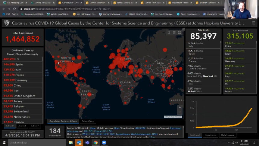
Map credit: Johns Hopkins University
By now you most likely recognize the interactive dashboard created by Johns Hopkins University used to geographically track coronavirus cases, deaths and recoveries.
The company that created the software and runs the hardware to power the dashboard is Redlands-based Esri, whose representative tells us the dashboard is currently receiving three million hits an hour from around the globe
“This virus is virtual and we need to put a face on it. One way to do that is through geography,” said Ryan Lanclous, Esri’s Director of Public Safety Solutions.
Esri’s software is used to make Geographic Information Systems, which are maps or visualizations based on data, which in most cases is constantly changing.
With countless applications, their technology is proving especially useful in the battle against coronavirus. providing thousands of decision makers around the globe at all levels data that can be used in the effort to “flatten the curve”, which the graph shows happening in China, but not yet in the United States.
“No matter what you believe you can look to the science and data that tells us we are still on the uptick of the event in the United States,” said Lanclous.
The coronavirus dashboard created by the World Health Organization is also powered by Esri.
The company which employs 4,500 people is making the tools available without charge to any entity or individual that wants to track data related to the coronavirus pandemic.
In some parts of the country, consumers are even using Esri’s technology to find critically needed supplies like toilet paper and water.
That’s the case with one dashboard set up by a local government in Cobb County Georgia for use by citizens.
The dashboard tracks store inventories based in part, on data provided by citizens using an app.
“Without having the real time reporting, we are behind the curve and behind the understanding that we need to allocate resources that are always scarce,” said Lanclous.
From hyperlocal to global, Esri is an inland empire company that s playing a key role in sharing and showing critical information during a pandemic.
