Fairview fire: 28,307 acres, 69% contained, two killed; Full containment expected Sept. 17
Update 6:00 p.m. Wednesday, Sept. 14
All remaining evacuation warnings have been lifted, Cal Fire announced.
The fire is 69% contained. Full containment is expected to happen by Saturday.
Update 4:00 p.m. Tuesday, Sept. 13
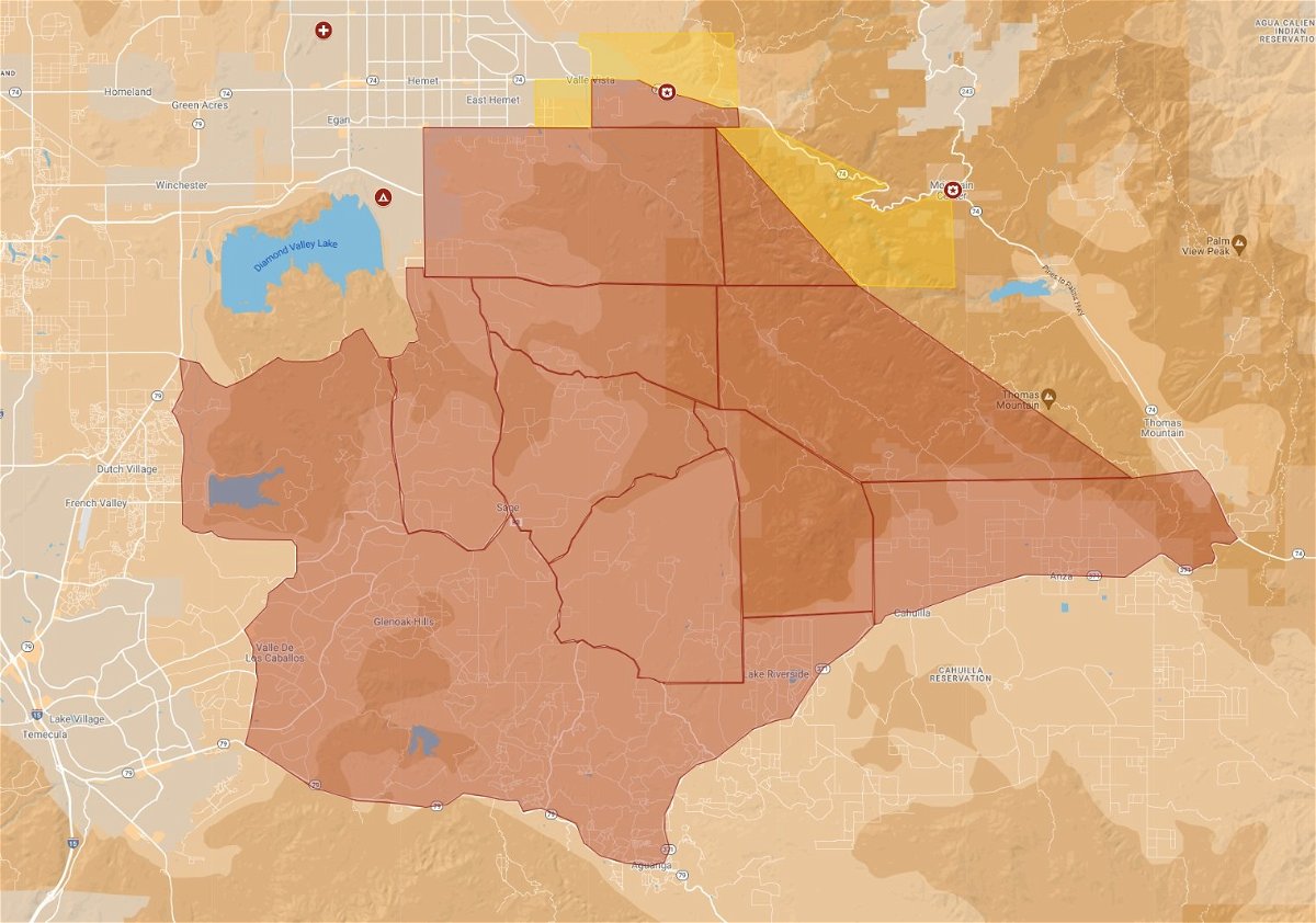
All remaining evacuation orders have been reduced to warnings. All previously issued evacuation warnings have been lifted, Cal Fire announced.
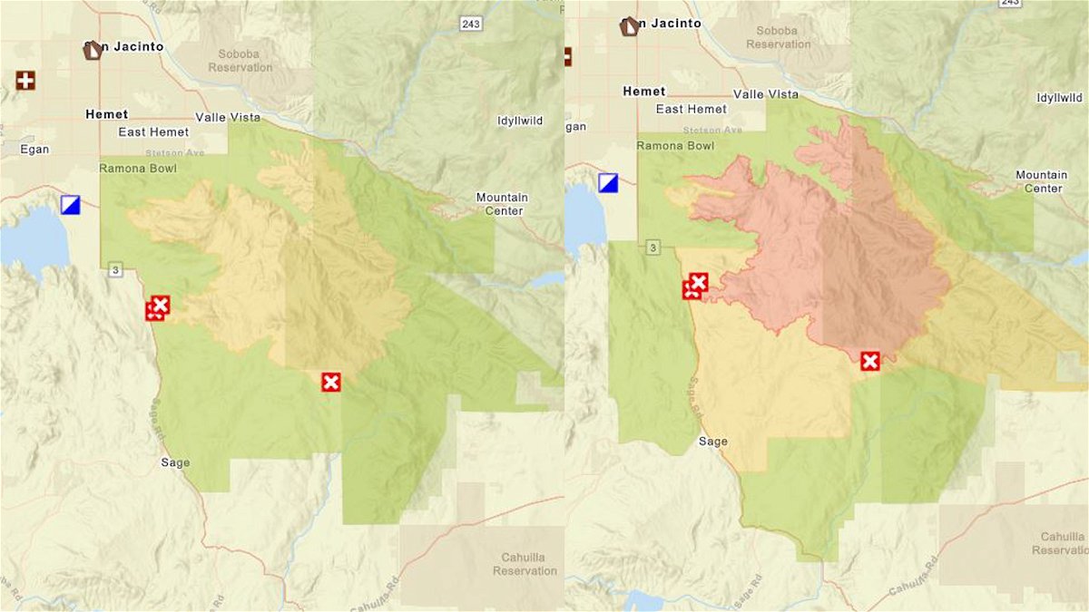
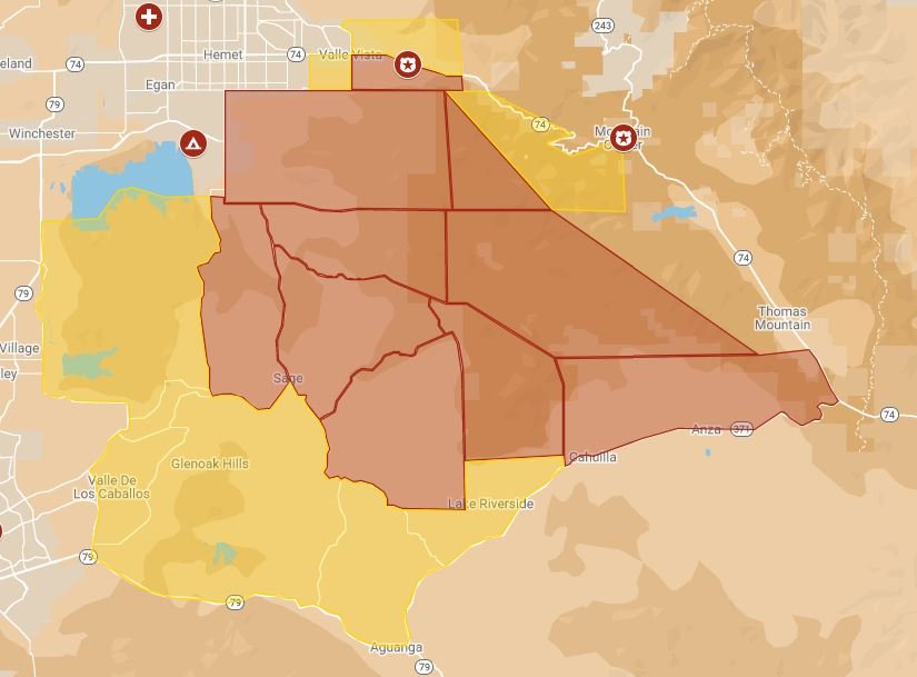
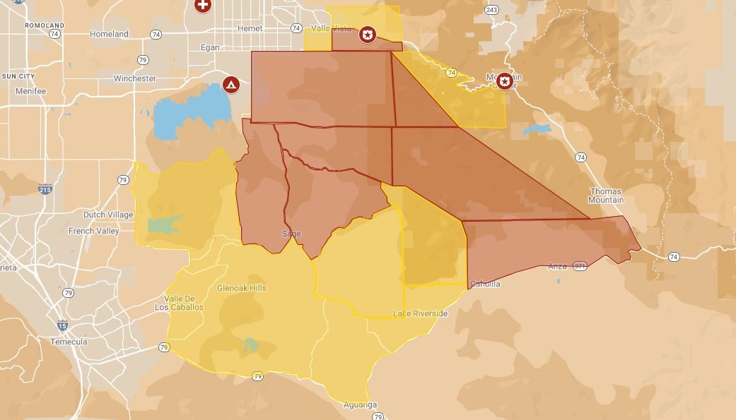
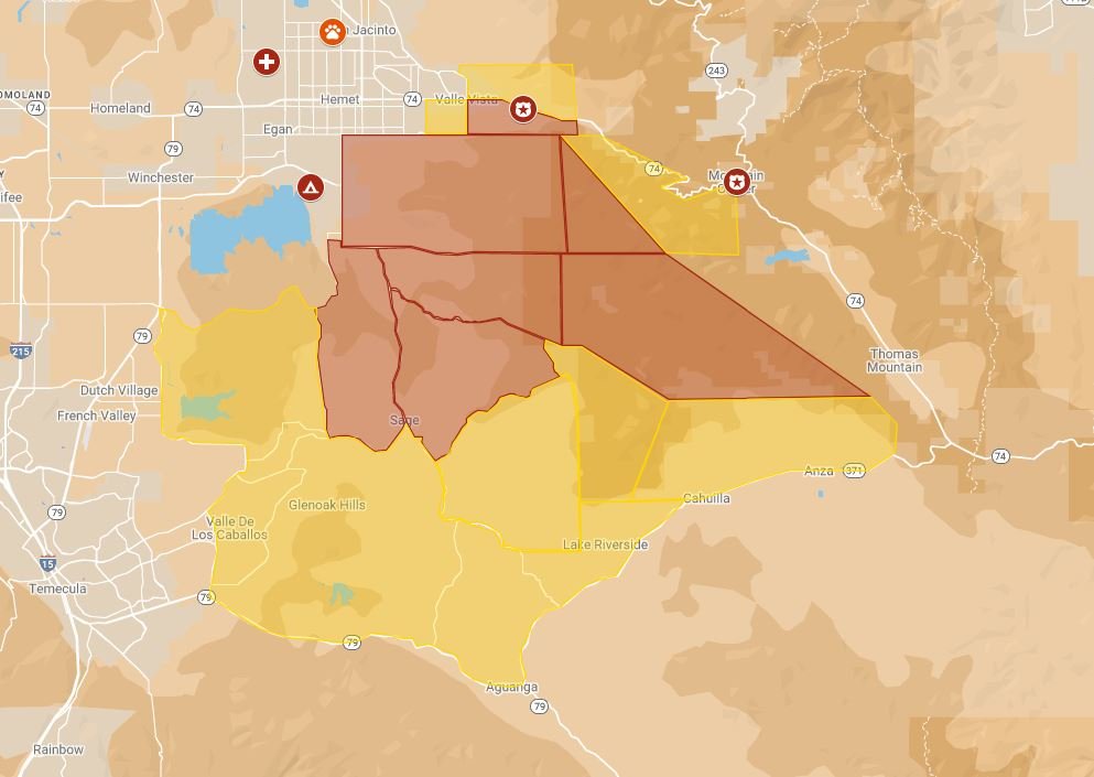
(Right) Evacuation map as of 9/13/22 prior to 4 p.m.
#FairviewFire | REDUCING EVACUATION ORDERS AND WARNINGShttps://t.co/Zfd1XMMpbfhttps://t.co/XM9d3OPpWA pic.twitter.com/i0RZ4Q53sb
— CAL FIRE/Riverside County Fire Department (@CALFIRERRU) September 13, 2022
Update 1:30 p.m. Tuesday, Sept. 13
The fire is now 62% contained. Officials said they expect the fire to be fully contained by Saturday, Sept. 17.
Update 7:00 p.m. Monday, Sept 12
Containment is now at 56%
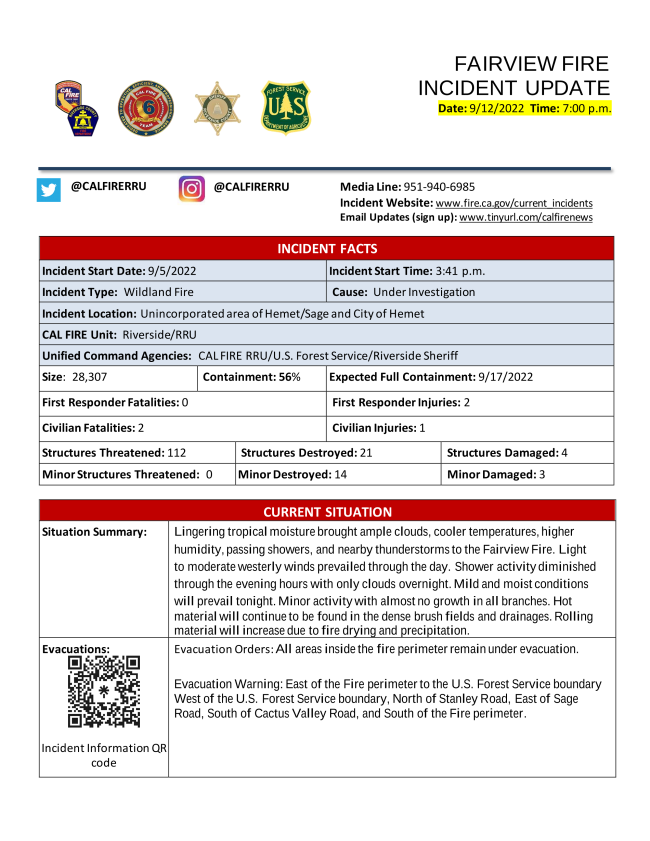
Update 5:00 p.m. Monday, Sept. 12
More evacuation orders were downgraded. In addition, more evacuation warnings were lifted.
REDUCED TO WARNING:
- East of the Fire perimeter to the U.S. Forest Service boundary
- West of the U.S. Forest Service boundary, North of Stanley Rd., East of Sage
Rd., South of Cactus Valley Rd., and South of the Fire perimeter
EVACUATION WARNINGS LIFTED: - West of Mountain Center, South of Hwy 74, East of Fairview Ave., South of
Stetson Ave., East of State St., North of Cactus Valley Rd., to the Fire
perimeter - West of Sage Rd., North of E. Benton Rd., East of De Portola Rd., South of
Cactus Valley Rd. - West of U.S. Forest Service boundary, North of Wilson Valley Rd., East of
Sage Rd., South of Stanley Rd.
EVACUATION WARNINGS LIFTED:
- West of Mountain Center, South of Hwy 74, East of Fairview Ave., South of
Stetson Ave., East of State St., North of Cactus Valley Rd., to the Fire
perimeter - West of Sage Rd., North of E. Benton Rd., East of De Portola Rd., South of
Cactus Valley Rd. - West of U.S. Forest Service boundary, North of Wilson Valley Rd., East of
Sage Rd., South of Stanley Rd.
Update 6:00 a.m. Monday, September 12
Representative Raul Ruiz is expected to visit the command center in Hemet on Monday morning.
The fire is marked at 28,307 acres and 53% contained. Cal Fire expects the Fairview Fire to be completely put out by September 17.
7:00 p.m. Sunday
Tropical moisture brought showers and thunderstorms to the Fairview Fire today. Some of these thunderstorms produced heavy rain and localized flooding. Rainfall amounts varied greatly from a trace to a few tenths of an inch. Showers and thunderstorms lingered through the evening before diminishing. Recent rains will bring excellent humidity recoveries tonight. Temperatures will remain mild overnight as well with relatively light winds.
EVACUATION ORDERS: The evacuation order encompasses the burn area.
- South of Cactus Valley Road
- East of Sage Road
- North of Stanley Road
- North of Diego
- Flat and Tripp Flats
- Northwest of Cottonwood Truck Trail
- West of Rouse Ridge to the burn area
- Bautista Road South of Fairview Avenue
Update 4:50 p.m. Saturday
Cal Fire is reducing evacuation orders and warnings were issued as of 4 p.m.
REDUCED TO WARNING: West of the U.S. Forest Service boundary, North of Wilson Valley Rd./Reed Valley Rd., East of Sage Rd., and Stanley Rd.
It also includes areas West of Sage Rd., North of E. Benton Rd., East of De Portola Rd., South of Cactus Valley Rd. and Larking Ln.
EVACUATION ORDERS WERE LIFTED IN THE FOLLOWING AREAS: South of Diamond Valley Lake, East of Washington St., North of Borel Rd., East of Rancho California Rd., East of Anza Rd., North of Temecula Pkwy (Hwy 79), Northwest of Hwy 371, and West of Hwy 74, South of US Forest Service Boundary, to include the Ramona Indian Reservation and Olivet University.
Update 8:20 p.m. Friday
Containment on the Fairview Fire jumped to 40% Friday night. The fire is now 28,307 acres.
Update 6:00 p.m. Friday
More evacuation orders were reduced to warnings in the past half-hour.
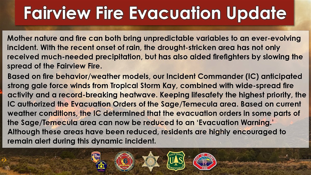
Cal Fire released a statement on how the recent rain has helped firefighters slow the spread of the Fairview Fire.
As of Thursday evening, the fire remains at 27,463 acres with 5% contained.
Update 5:30 p.m. Friday
Some evacuation orders have been reduced, Cal Fire announced.
The reduction extends to:
EVACUATION WARNING: - South of Diamond Valley Lake, East of Washington St., North of Borel Rd., East of Rancho California Rd., East of Anza Rd., North of Temecula Pkwy (Hwy 79), Northwest of Hwy 371, and West of Hwy 74, South of US Forest Service Boundary. - The Community of Ramona Village and Olivet University
Update 2:04 p.m. Friday
Firefighters battling the Fairview fire had to pause operations overnight in order to rescue people from inside the evacuation order zone, News Channel 3 has learned.
Some residents decided to stay inside their homes even into the third day of evacuation orders, reported Justin McGough, Day Operations Branch Chief on the Fairview Incident. The residents grew worried and called 911 as the flames moved closer to them.
McGough explained the prolonged overnight battle included areas that had been under evacuation order for three days "when the fire impacted those homes. Those residents called 911 because they were trapped by fire. We had to stop our operation ... had to put firefighters in harm's way to remove people that had chosen to stay home in an area that had been under an evacuation order."
"We want you out of harm's way so that we don't have to continue to put our firefighters in increased harm's way to go in and get you into areas that we thought were previously unoccupied."
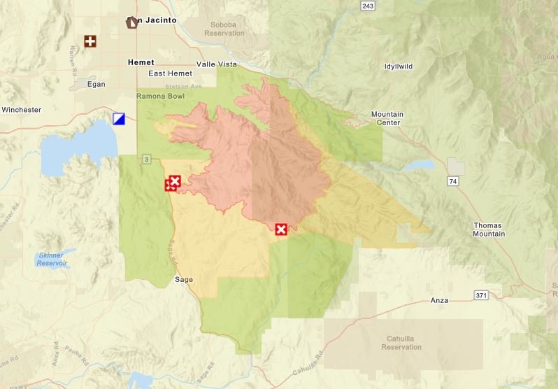
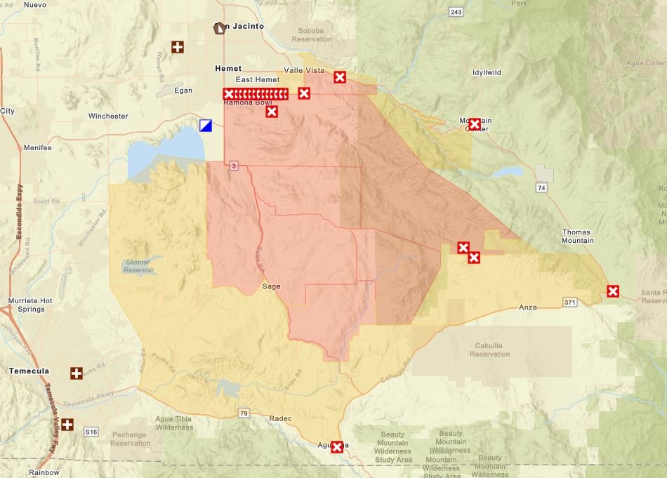
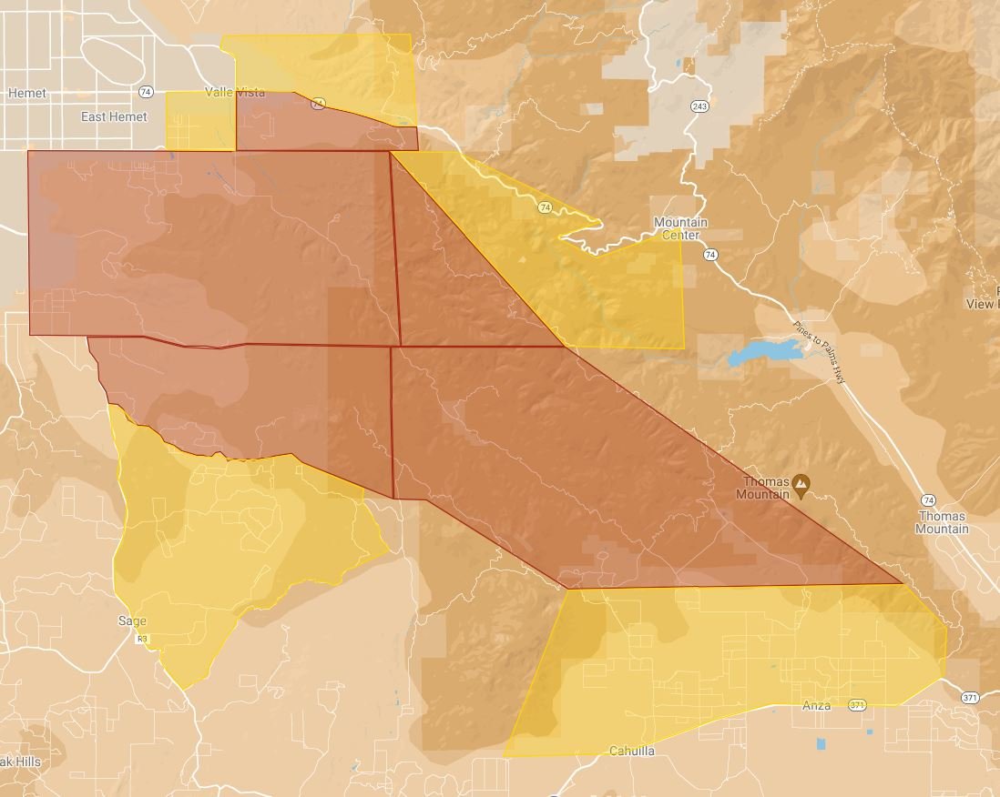
A new evacuation map is available.
Check out Cal Fire's updating interactive evacuation map below:
6:30 a.m. Friday
The fire is 27,463 acres and 5% contained. Over 2,143 personnel are now assisting with the Fairview fire. The US Forest Service closed several public hiking areas to aid firefighters and protect public safety during the Fairview Fire. A statement said, "forest lands in the Bautista Canyon, Rouse Ridge, and Thomas Mountain areas, as well as the South Fork of the San Jacinto River Wilderness Area and the Cahuilla Mountain Wilderness are closed to entry." Bautista Canyon Road and Forest Roads 5S15 (Rouse Ridge), 6S13 (Thomas Mountain), 6S16 and 6S18 (Cottonwood Canyon) and 6S22 (Cahuilla Mountain) have been closed to the public. The Alessandro and Hixon OHV routes and the South Fork, Ramona, and Cahuilla Mountain hiking trails have also been closed.
10:15 p.m. Thursday
The fire is 27,319 acres and 5% contained.
8:30 p.m. Thursday
Evacuation orders were expanded to areas south of Sage. The areas had been under an evacuation warning since early this morning.
The new evacuation orders extend to:
- South of Diamond Valley Lake, East of Washington St., North of Borel Rd., East of Rancho California Rd, East of Anza Rd., North of Temecula Pkwy (Hwy79), Northwest of Hwy 371, and West of Springbrook Rd.
6:00 p.m. Thursday
Cal Fire officials are holding a community meeting in Temecula. You can watch the meeting below:
Community Meeting | Fairview Fire | September 8, 2022 https://t.co/KFg2L4hOiJ
— CAL FIRE/Riverside County Fire Department (@CALFIRERRU) September 9, 2022
Update 5:15 p.m. Thursday
The Fairview Fire has now been mapped at 23,919 acres, according to FIRIS.
OES Intel 24, Sept 8th on the #FairviewFire, RRU. Fire is mapped at 23,919 acres at 15:16 hours. Video #1 pic.twitter.com/sSPIYE9iSa
— FIRIS (@FIRIS) September 9, 2022
Update 4:55 p.m. Thursday
Highway 74 has been shut down at Bighorn Drive.
CHP officers said residents will be allowed to go up the hill but they have to show proof of residency.
#BREAKING: Hwy 74 closed in both directions near Palm Desert due to #FairviewFire. Residents required to show proof of residency going up the hill 🚨 @KESQ pic.twitter.com/vMf89AVBiP
— Samantha Lomibao KESQ (@samanthaKESQ) September 9, 2022
A new evacuation order has been issued for:
- West of Hwy 74, North of 371, East of Springbrook Rd, South of US Forest Service Boundary
Update - 1:00 p.m Thursday
The fire is at 18,657 acres and 5% contained. The acreage went down due to more accurate mapping, Cal Fire officials said.
Evacuation orders were expanded to:
- East of De Portola Rd., West of Sage Rd., North of East Benton Rd., and South of Diamond Valley Rd.
Update - 12:00 p.m. Thursday
New Evacuation Warnings have been ordered by CalFire EVACUATION WARNING:
- South of Rawson Rd., East of Washington St., North of Borel Rd., East of
Rancho California Rd, East of Anza Rd., North of Temecula Pkwy (Hwy79),
Northwest of Hwy 371, and West of Hwy 74
Update - 7:00 a.m. Thursday
The Fairview Fire remains at 19,377 acres with 5% containment. 1,100 firefighters are helping put the fire out. Cal Fire has called on additional resources to arrive within the day.
A portion of Anza remains under an evacuation warning.
Numbers regarding containment and acres burning are expected to change today.
10:45 p.m. Wednesday
The Farview Fire is now at 19,377 acres with 5% containment
9:45 p.m. Wednesday
EVACUATION ORDER: - West of Wilson Way, South of Hwy 74, East of Fairview Ave., North of Stetson
EVACUATION WARNING: - West of Fairview, South of Hwy 74, North of Stetson, East of Soboba St. - East of Fairview, North of Hwy 74, South of San Jacinto River bed, East of Wilson Way.
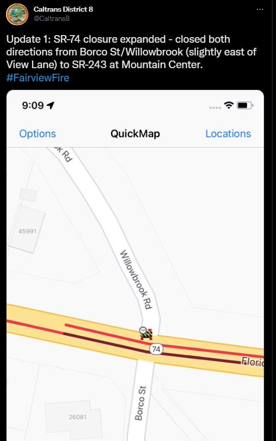
Update 9:00 p.m. Wednesday
Highway 74 has been shut down in both directions from Borco St/ Willowbrook to SR 243 at Mountain Center, CalTrans announced.
Fire officials listed a projected 48-hour outlook for the fire on Inciweb, an information system:
- 12 hours: Fire activity will moderate slightly overnight with increased humidity and decrease in temperature. Active burning will continue on the east, south, and west areas.
- 24 hours: Shifting winds from the west will allow the fire to actively burn to the east, into heavier fuels and steeper slopes. Spotting will continue to be over .50 miles in the dense brush.
- 48 hours: Activity will increase with the approach of Tropical Cyclone Kay from Baja. This event will produce 35mph east winds and strong down canyon gusts over the San Jacinto mountains, allowing for increased spotting and fire spread in the southern, and western areas of the incident.
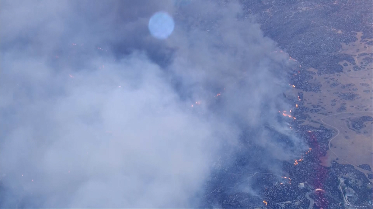
Update 4:30 p.m. Wednesday
Fairview Fire increased to 9,846 acres. The blaze remains 5% contained.
Evacuation orders/warnings were expanded:
EVACUATION ORDER 9/7/22 4:00 p.m.:
- South of Cactus Valley RD., North of Minto way, North of Red Mountain RD, West of US Forest Service Boundary, and East of Sage Rd.
EVACUATION WARNING 9/7/22 4:00 p.m:
- East Red Mountain RD, and the Cahuilla mountain US forest service boundary
- South of Minto Way, South of Red Mountain Rd, West of Stanley Rd., and North of Stanley RD., and East of Sage Rd.
Check out Cal Fire's updating interactive evacuation map below:
Update 2:30 p.m. Wednesday
Riverside County proclaimed a local emergency in response to the Fairview Fire.
The emergency proclamation could help make the county eligible for potential federal and state assistance and cost reimbursement. In addition, the proclamation allows the county to more easily procure needed services and items to respond to the emergency.
See the emergency proclamation signed by County Executive Officer Jeff Van Wagenen here.
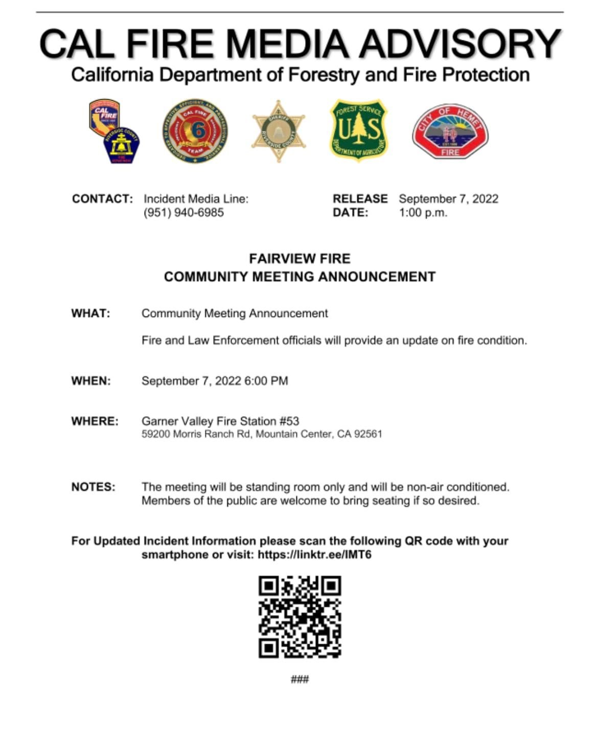
Cal Fire is hosting a community meeting at 6 p.m. at the Garner Fire Station Fire and law enforcement officials will share an update on fire condition.
Update 10:30 a.m. Wednesday
The Fairview fire is 7,091 acres and 5% contained. All evacuation orders and warnings remain in place.
Update 5:15 a.m. Wednesday
The Fairview Fire grew to 5,000 acres overnight with 5% containment, according to a morning media briefing from CalFire. The state is calling on the US Forest Service to help with additional resources to stop the flames.
Update 5:15 p.m. Tuesday
The Fairview Fire has grown to 4,500 acres, Cal Fire announced. Containment is holding at 5%.
The cause of the fire was under investigation. In a document filed with the California Public Utilities Commission, Southern California Edison reported "circuit activity" in the area close to the time the fire erupted.
"Yesterday, we submitted an initial Electric Safety Incident Report (ESIR) to the California Public Utilities Commission (CPUC) on the Fairview Fire," said Dave Eisenhauer, spokesperson for SCE. "Our information reflects circuit activity occurring close in time to the reported time of the fire."
Update 4:50 p.m.
The evacuation orders and warnings have continued to spread east into the Mountain Center area.
Cal Fire's interactive map shows the order has spread further into the mountain. An evacuation warning has gone up, heading into Highway 74 a little west of Mountain Center and south to Highway 371 heading towards Anza and Cahuilla.
#FairviewFire [UPDATE] 4:45 pm -NEW EVACUATION ORDERS: Thomas Mountain Ridge South to Cactus Valley to Bautista Cyn to forest boundary.
— CAL FIRE/Riverside County Fire Department (@CALFIRERRU) September 6, 2022
NEW EVACUATION WARNINGS: South of Hwy 74 to Thomas Mtn. W of Mountain Center N of Cactus Vly. Anza N of Hwy 371 to Forestry Boundary. pic.twitter.com/GkqN7QVx7z
Update: 2:50 p.m.
The Fairview Fire has now burned 4,000 acres. Containment remains at 5%
Update 2:00 p.m.
According to the Fire Integrated Real-Time Intelligence System (FIRIS), the fire has now burned 3,458 acres.
OES Intel 24, Sept 6th on the #FairviewFire, RRU. Fire is mapped at 3,458 acres at 13:07 hours. pic.twitter.com/HOZF2JRMwc
— FIRIS (@FIRIS) September 6, 2022
FIRIS is a public-private partnership program that provides real-time intelligence data and analysis on emerging disaster incidents in California.
Update 6:30 a.m.
The fire is 2,400 acres and 5% contained. The evacuation orders and warnings remain in place.
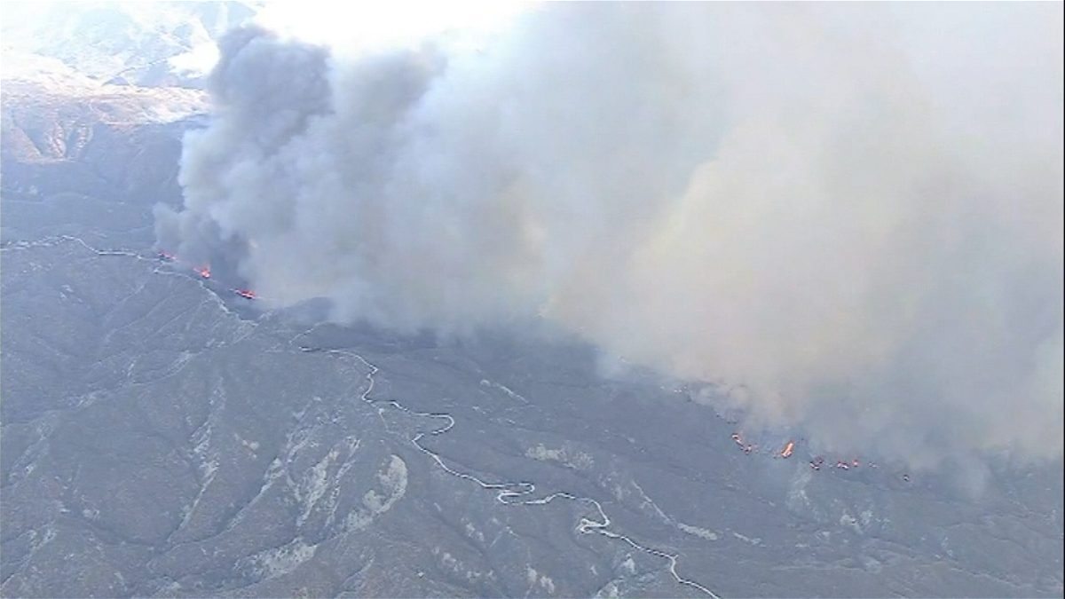
Original report 9/5/22
Two civilians are dead after in a vegetation fire that has grown to 2000 acres Monday near Bautista Canyon south of Hemet.
As of 7:45 p.m., Cal Fire confirmed the blaze was 5% contained. In addition to the fatalities, one civilian was injured.
According to Cal Fire, 7 structures have been destroyed. Several more have been damaged.
The Fairview Fire was initially reported at around 3:40 p.m. in the area of Fairview Avenue and Bautista Road, near Bautista Canyon.
At around 4:05 p.m., Cal Fire reported the fire was at 20 acres of light to medium vegetation burning at a rapid rate.
By 4:50 p.m., Cal Fire confirmed that the fire had grown to 500 acres.
#fairviewFIRE [UPDATE] The fire is approximately 500 acres, burning at a rapid rate of spread.
— CAL FIRE/Riverside County Fire Department (@CALFIRERRU) September 5, 2022
Cal Fire issued evacuation orders for residents living near the area. Those orders were expanded to more communities later in the evening.
#FairviewFIRE Evacuation ORDER EXPANSION: South of Stetson, North of Cactus Valley Road, West of Fairview Avenue, East of State Street. Interactive map: https://t.co/0jII9tEIFP
— CAL FIRE/Riverside County Fire Department (@CALFIRERRU) September 6, 2022
A care and reception site has been established at Tahquitz High School: 4425 Titan Trail, Hemet pic.twitter.com/PLdMheSN26
The cause of the fire remains under investigation.
265 firefighters, 6 air tankers, 4 helicopters, and 38 engine companies from a variety of fire agencies were deployed to the fire.
Stay with News Channel 3 for continuing updates.