LA/San Diego county fires fully contained

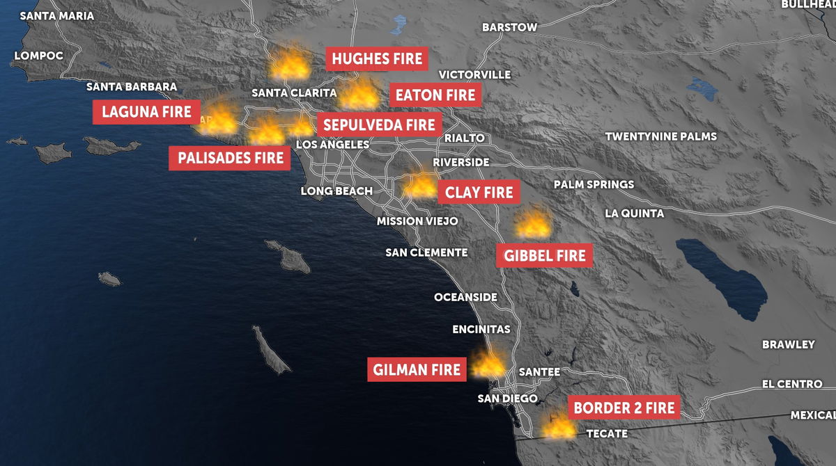
1/31/25 - Palisades fire, Eaton fire, Hughes fire, Border 2 fire are 100% contained.
1/28/25
8:25 a.m. - The Border 2 Fire is now 74% contained
8:00 a.m. - California fire victims could recover damages from oil companies under proposed law. It would create a new pathway for victims of wildfires and insurance companies to sue oil companies over climate change.
1/27/25
6:50 p.m. - The Border 2 Fire is now 55% contained
5:00 p.m. - Attorneys who contend Southern California Edison equipment sparked the Eaton Fire pointed to newly released video that they believe is evidence the utility's transmission lines were the source of the inferno.
Attorneys from the Edelson law firm posted a surveillance video online taken from an Altadena gas station that the lawyers contend shows SCE power lines arcing during the Jan. 7 windstorm, and sparks subsequently falling to the ground. Within minutes, flames can be seen on the hillside.
We've obtained video that indicates the Eaton Fire in Los Angeles started after an apparent arc on SoCal Edison lines. We're back in Court for a hearing tomorrow fighting to make sure that SoCal Edison keeps all the evidence that we will put before a jury in this case.… pic.twitter.com/dihnMMQu3Z
— Edelson PC (@edelsonpc) January 26, 2025
4:45 p.m. - A 29th death associated with the wildfires has been reported by the Los Angeles County Medical Examiner. The death of the unidentified person, who died in a hospital, is connected with the Palisades Fire, putting the death toll from that blaze at 12
1:00 p.m. - The final evacuation areas within the Palisades Fire burn zone have been lifted, allowing residents only to return to the area
10:00 a.m. - Much-needed rainfall helped firefighters extend containment lines
- Palisades Fire - 23,448 acres, 94% contained
- Eaton Fire - 14,021 acres, 98% contained
- Hughes Fire - 10,425 acres, 95% contained
- Border 2 Fire - 6,625 acres, 43% contained
Check Out Our Resources Guide for Ways to Help Those Impacted
Palisades Fire - 23,448 acres, 100% contained
The Palisades Fire was the first major fire to start up on January 7, reported at just before noon. As of January 31, it has burned over 23,000 acres and is now 100% contained.
At least 12 people have died in the Palisades Fire. One firefighter was injured, along with three civilians, according to fire officials.
It's been estimated that 6,837 structures had been destroyed by the blaze, and another 1,017 damaged.
The cause of the fire remains under investigation.
Eaton Fire - 14,021 acres, 100% contained
The Eaton Fire was reported about 6:20 p.m. on January 7 in the area of Altadena Drive and Midwick Drive in the hills above Altadena amid hurricane force Santa Ana winds, according to Cal Fire.
As of January 31, the fire's size was 14,021 acres and is now 100% contained.
It has destroyed 9,418 structures and damaged another 1,073.
At least 17 deaths have been attributed to the Eaton Fire, according to the LA Medical Examiner. Nine injuries have been confirmed.
The cause of the fire has not been determined, however, on January 13, three lawsuits were filed against Southern California Edison over allegations it was started by equipment failure.
Hughes Fire - 10,425 acres, 100% contained
The Hughes Fire was reported at about 11 a.m. January 22 in the area of Lake Hughes Road near the Golden State (5) Freeway near Castaic Lake, according to Cal Fire.
Aided by gusting Santa Ana winds and thick, dry vegetation, the fire quickly gobbled up 500 acres of brush, but within 90 minutes, it was estimated at more than 3,400 acres.
As of January 30, the fire has burned 10,425 acres and is now 100% contained.
Border 2 Fire (San Diego Co.) - 6,625 acres, 100% contained
The Border 2 Fire broke out for unknown reasons shortly before 2:30 p.m. January 23 in a remote spot near Otay Mountain Truck Trail, about a half-mile west of Doghouse Junction in Otay Mountain Wilderness Area, according to Cal Fire.
As of January 30, it has burned 6,625 acres and is now 100% contained.
2,169 structures were threatened, but none were damaged or destroyed, according to Cal Fire. There have also been no injuries reported.
Hurst Fire - 799 acres, 100% contained
The Hurst Fire was reported around 10:30 p.m. on January 7 in the 5900 block of Yarnell Street, and within a half-hour, it had burned more than 100 acres, Los Angeles Fire Department spokeswoman Margaret Stewart said.
As of January 16, the fire was 100% contained.
Woodley Fire - 30 acres, 100% contained
The fire was initially reported at 75 acres just before 4 a.m. January 8, at the park located near the Ventura (101) and San Diego (405) freeways, according to the Los Angeles Fire Department.
CalFire reports as of January 8, the Woodley Fire was 100% contained.
Lidia Fire - 395 acres, 100% contained
The Lidia Fire burned 395 acres of terrain in the Acton area, threatening structures. It erupted early afternoon on January 8 in the area of Soledad Canyon Road and Bootleggers Canyon
As of January 11, the containment of the Lidia Fire was 100%, according to Governor Gavin Newsom.
Sunset Fire - 43 acres, 100% contained
The Sunset Fire started up at around 5:30 p.m. on January 8 in the Hollywood Hills. It burned approximately 43 acres between Runyon Canyon and Wattles Park.
In the morning of January 9, Los Angeles city officials officials confirmed the fire was 100% contained.
Kenneth Fire - 1,052 acres, 100% contained
The fire was reported around 3:30 p.m. on January 9 in an area north of the Ventura (101) Freeway near Valley Circle Boulevard. Initially reported at 20 acres, it quickly expanded to 50 acres, and within three hours, it exploded to more than 1,000 acres, pushed by continuing Santa Ana winds.
By the morning of January 12, the fire was 100% contained.
The fire is being investigated as a possible arson, according to the Los Angeles Police Department. A person has been detained.
LAPD investigators and deputies from the Ventura County Sheriff's Department interviewed the man and determined there was "not enough probable cause'' to arrest him as a possible arson suspect. The man was, however, arrested on suspicion of a felony probation violation.
His name was not released.
No structures were damaged by the Kenneth Fire.
Archer Fire - 19 acres, 100% contained
The fire was first reported at 10:25 a.m. on January 10 as a 2- to 3-acre blaze in the 17200 block of West Sesnon Boulevard, according to the Los Angeles Fire Department's Margaret Stewart.
The fire grew to 31 acres, but it was later mapped at 18.8 acres by FIRIS OES INTEL 24.
The fire was fully contained the same day.


