Wind Advisory issued December 23 at 12:39AM PST until December 25 at 2:00AM PST by NWS Las Vegas NV
UpdatedWind Advisory: Western Mojave Desert; Morongo Basin until Dec 23 at 12:27 PM
Continue ReadingWind Advisory: Western Mojave Desert; Morongo Basin until Dec 23 at 12:27 PM
Continue ReadingWind Advisory: San Bernardino County Mountains, Riverside County Mountains, San Diego County Mountains and 4 more areas until Dec 23 at 10:42 AM
Continue Reading
Highs were a bit cooler than we expected this afternoon! Upper-level clouds hung over the Coachella Valley today, which capped our temperatures in Palm Springs at 75° for today – closer to seasonal averages than we had thought. Less of these clouds are expected for tomorrow, so temperatures should warm as we start the week.
Continue Reading
Yesterday was the winter solstice, marking the formal (astronomical) start of winter. The earth’s tilt is responsible for giving us seasons. In the northern hemisphere, we are tilted slightly away from the sun. This marks our coolest part of the year and marks the shortest day/longest night of our year. We are tracking an area
Continue Reading
Today marks the winter solstice: the shortest day of the year, and the official start to astronomical winter! Despite “winter” bringing images of cooler weather and more precipitation, neither of those are true for the Coachella Valley this weekend! It’s pleasant and mild as Christmas draws closer. Over the past few days, Palm Springs has
Continue Reading
Another exceptionally warm late December day in Palm Springs as the Coachella Valley continues our unusually mild trend with temperatures breaking records the last two days. Yesterday and Wednesday, we hit 85 degrees, and today, we’re likely to surpass the 82-degree mark set as the record for this date. We’ve already tied it as of
Continue Reading
Late December continues to amaze us with a string of high temperature records. We clocked 85 degrees again yesterday, setting another record in Palm Springs. Today, the record to break is 82 and it seems likely we’ll get to that number. Highs are expected meet or exceed that number later this afternoon. If you’re flying
Continue Reading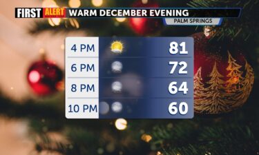
Record breaking temps for Palm Springs and the Coachella Valley Wednesday, with more records possible today! Highs hit 85 in Palm Springs yesterday and 84 in Thermal, both beating previous records from 1985. Palm Springs also woke up to record warm low overnight temps Wednesday morning. THURSDAY: Enjoy mild temperatures with daytime highs in the
Continue Reading
Highs hit 85 in Palm Springs yesterday and 84 in Thermal, both besting previous records from 1985. We’ll be close that again today and records are in jeopardy as high pressure continues to push the Jetstream FAR to the North, allowing the Western U.S. to see hotter than normal conditions, while the Eastern U.S. will
Continue Reading
12am Update: We tied the daytime high record and broke the record for warmest overnight low. Previous discussion: Santa Ana winds gradually decrease through Thursday morning, but locally breezy east to northeasterly winds and low relative humidity lingers, leading to elevated fire weather conditions–especially along the Coast. Currently much of Los Angeles and Ventura counties
Continue Reading
Santa Ana Winds continue today but will gradually ease through the afternoon and evening. The winds are the result of a large ridge of high pressure across the Western states. The gusty winds peaked overnight, but fire danger is still quite high throughout SoCal, especially in the mountains and coastal areas near Los Angeles. A
Continue Reading
Unusually warm with above-normal temperatures for Palm Springs and most of the Coachella Valley this week thanks to high-pressure over Northern Nevada. This keeps temperatures in the region 10-15 degrees above average, with highs climbing to the low 80s today and for most of the week–especially in our Palm Springs, Cathedral City, and Rancho Mirage
Continue Reading
Those pesky Santa Ana Winds return to the forecast, creating increased fire danger, especially in areas north of Los Angeles. A Red Flag Warning is posted for northern L. A. county and Ventura county as well. High pressure is centered over the Great Basin, which will encourage Northeasterly winds across the region. Highs today will
Continue Reading
Fair and warmer weather this week for the Coachella Valley, with temperatures peaking in the low 80s by Wednesday and Thursday. A weak to moderate Santa Ana wind event will develop starting Tuesday and continuing through Wednesday, bringing northeasterly winds of 35-50 mph to parts of the region, particularly from the Cajon Pass southward. Winds
Continue Reading
Despite a pretty significant front moving through to our North, weather here in the Valley will remain quite mild all week long with highs approaching 80! The front will produce some messy winter weather from Northern California to Washington State. Here in Southern California, a Fire Weather Watch is in effect north of Los Angeles
Continue Reading
A mild Sunday with plentiful sunshine here in the desert is coming to a close! We are also well into the warming trend that will likely bring highs back to the 80s this week. The upper level clouds we were tracking yesterday and overnight have given way to clear skies this afternoon. Drier air has
Continue Reading
It is predominantly clear this morning with the exception of a few upper-level clouds passing overhead. We are tracking fewer of those clouds right now, closer to sunrise. Skies will stay predominantly clear across the Coachella Valley today. Looking at the temperature outlook, we can see a lot of warm colors over the west coast.
Continue Reading
There’s a slight breeze and some clouds above the Coachella Valley this afternoon. More clouds will move in overnight, but they should continue to decrease through tomorrow afternoon. Storm systems continue to impact Northern California, but they’re staying to our north. The only impacts we’re seeing are some additional atmospheric moisture and slightly breezy conditions.
Continue Reading
We’re wrapping up the work week on a mild note with calmer conditions and a mix of high clouds and sun. Pretty nice day around the valley. Here’s a look at some of our valley cameras just before 3pm: Tonight, high clouds will increase, partially clearing Saturday afternoon. Winds will pick up just a bit
Continue Reading
This morning we are tracking some very chilly temperatures and some lingering breezes. Thankfully, winds are continuing to decrease through the early morning hours. Overall, we are tracking very mild conditions today for the Coachella Valley. More low pressure systems will move into California in the coming days but will stay too far north to
Continue Reading